In the 11th year of the Guangxu reign (1885) the Qing court dispatched Zhou Derun (1832-1892) and Cen Yuying (1829-1889) as border survey officials to join their French counterparts Charles Dillon (n.d.) and Bernard Franҫois Justin Tisseyre (1838-1937) to demarcate and map out the borderline between Yunnan and Vietnam. However, delegates from both sides held different opinions, and it was not until the 6th month of the following year (1886) that they met to discuss details on border survey. Yet, due to a series of subsequent incidents such as French military officials being robbed at the border and envoys becoming ill or being wounded, their on-site survey came to a halt. Following another round of negotiations, the two sides decided to draw the borderline on map, instead of conducting field survey at the sites. In the 9th month of the 12th year (1886), Zhou Derun and Charles Dillon met at Ho-k'eou to look over the map and mark out the borderline. They went on to sign five memoranda relative to Sino-Vietnamese border survey in Yunnan, accompanied by five corresponding border maps. Unfortunately, the two sides disagreed over the border mapping of the 2nd and 5th sections. Delegates were then re-deployed to conduct joint on-site border survey, and their agreements were later incorporated into the Convention between China and France Respecting the Delimitation of the Frontier between China and Tonkin signed in the 5th month of the 13th year of the Guangxu reign (1887).
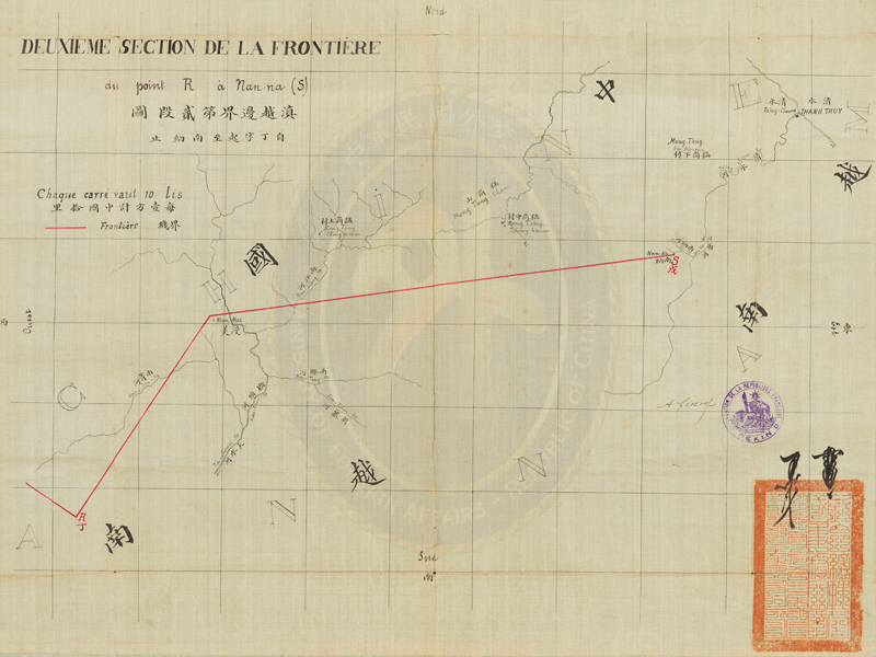
Map of the Second Section of the Sino-Vietnamese Border in Yunnan (with Borderline between Points R and S Re-drawn)
- 21st year of the Guangxu reign, Qing dynasty (1895)
- 42.8 x 56.2 cm
This map is oriented with north at the top, south at the bottom, west at the left, and east at the right. The French words on the top left corner are translated as "Second Section of the Border" and "From Point R to Nan-na." The red borderline starts at point R and extends northeastwards to Man-mei, where it turns to the east and reaches Nan-na (point S). Man-mei was assigned to Vietnam, and the three villages in Meng-toung (Muong-dong) to the north of the border to China. On the bottom right of the map are the initials of Yikuang, Prince Qing, and Xu Yongyi (1826-1900) with the official seal mark of the Zhongli Yamen, as well as the signature of French envoy Auguste Gérard (1852-1922) and the seal mark of the French Legation in Beijing. This map is therefore an official instrument of the Convention Complimentary to the Convention between China and France Respecting the Delimitation of the Frontier between China and Tonkin.
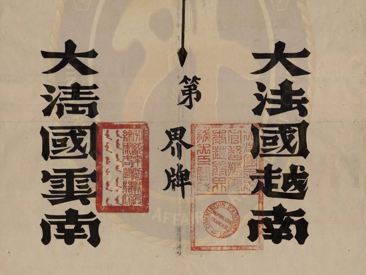
Treaty Regarding the Yunnan-Vietnam Border between China and France
- Signed on the 14th day of the 5th month in the 23rd year of the Guangxu reign (June 13, 1897)
- 23.5 x 27 cm
- 48.5 x 40 cm (sample 1 of border signpost)
- 31.6 x 18.6 cm (sample 2 of border signpost)
The Treaty Regarding the Yunnan-Vietnam Border between China and France held in trust by the National Palace Museum for the Ministry of Foreign Affairs is made up of a Chinese version of the copy of the Treaty as well as the signed and initialed survey records of the four border sections - documents relevant to the joint expeditions and the erection of the signposts left from the period following the signing of the Treaty. The item shown here is not the Treaty Regarding the Yunnan-Vietnam Border between China and France itself. The title "Border Treaty and Maps" seen on the cover is likely an error.


