:::

Erecting Signposts along the Sino-Vietnamese Border in Eastern and Western Guangxi

The Chief Minister Deng Chengxiu (1841-1892) of the Office of Diplomatic Reception and the French commissioner for border survey Charles Dillon (n.d.) signed an agreement in Móng-cái on Sino-Vietnamese border demarcation between Guangdong's Tchŏu-chan (Trúc-son) and Guangxi's Ko-ta-cheng, and produced four preliminary maps for the four sections stipulated in the agreement. Though both sides determined their respective borderlines in accordance with the maps, the signed agreement only provided brief accounts of the borders, which did not fully reflect the actual geographic and topographic features. As for the erection of border signposts, disagreements persisted between the two sides. It was not until the 7th month in the 16th year of the Guangxu Reign (1890) that France dispatched Hippolyte Frandin (1852-1924) as the representative in charge of negotiating border signposting, while the Qing court assigned Prefect Xiang Wanheng (n.d.) of the Wuzhou Prefecture and Intendent Cai Xibin (1832-1900) of the Taiping Sishun Circuit to the tasks of erecting signposts along the Sino-Vietnamese border in eastern and western Guangxi, from the Thên-sang-shā Mountain to Bi-nhi and between Bi-nhi and Ko-ta-cheng, respectively.

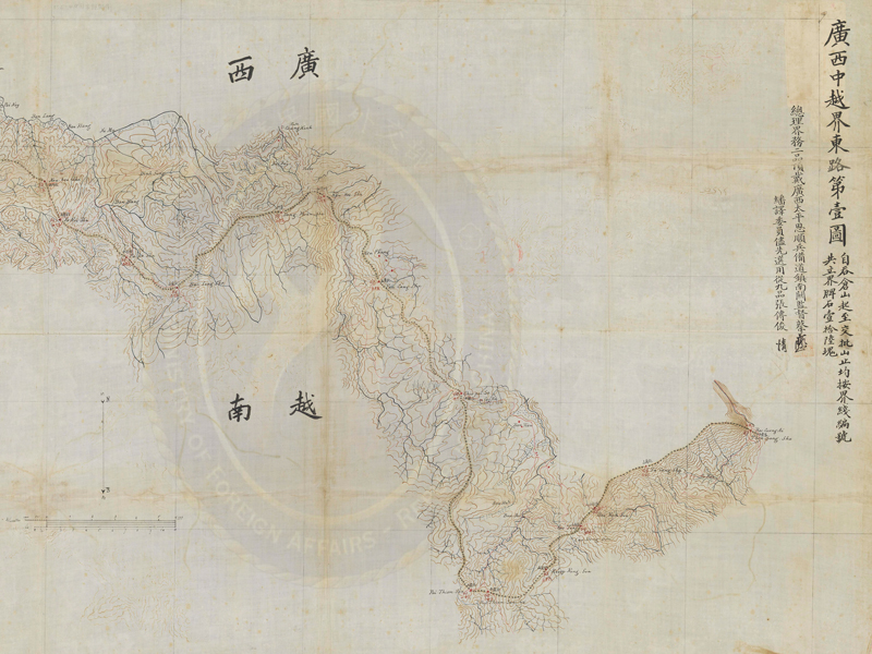
Map of the Sino-Vietnamese Border in Eastern Guangxi (No. 1)

Map of the Sino-Vietnamese Border in Eastern Guangxi (No. 1)

  1. 20th year of the Guangxu reign, Qing dynasty (1894)
  2. 61 x 97.5 cm
Bearing the initials, signatures, and seal marks of both Chinese and French border survey representatives, this map is oriented with north at the top, south at the bottom, west at the left, and east at the right. The note reads, "Starting at the Thên-sang-shā Mountain and ending at the Chio-py-thã Mountain, a total of 16 signposts were put up along the border." The borderline begins with the 51st signpost in the second map and extends to the 52nd at the Chio-py-thã Mountain on this map. It then continues further southeastwards to the 62nd at the Pai-thiem-son Mountain, and takes a turn to the northeast to the 67th at the Thên-sang-shā Mountain.
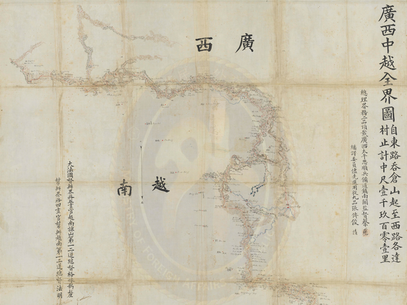
Comprehensive Map of the Sino-Vietnamese Border in Guangxi

Comprehensive Map of the Sino-Vietnamese Border in Guangxi

  1. 20th year of the Guangxu reign, Qing dynasty
  2. 95.5 x 106.5 cm
The map is oriented with north at the top, south at the bottom, west at the left, and east at the right. To the right is a note that reads, "From the Thên-sang-shā Mountain in eastern Guangxi to Ko-ta-cheng in the west the borderline is 1,901 Chinese li in length," along with the official titles of Cai Xibin, Zhang Chuanjun, and French border survey representatives, as well as their initials and signatures. As such, it is considered an official border map between Qing China and France. The red borderline starts at Bac-cuang-ai, the Thên-sang-shā Mountain, in the southeast, and heads northwestwards before turning north and northwest to reach Na-bô. It then continues in the northwest direction until arriving at the border between Vietnam and the province of Yunnan. The borderline on the map is not marked with the sites of the signposts. The map is likely to be a Chinese-language version brought back by Cai for presentation to the Qing court.